Historical Images & Maps
Maps
 |
 |
 |
||||
December 1883 Sanborn fire insurance map for Bloomfield Iowa. The map shows the eight blocks that surround the town square. Download a Detailed PDF Here. |
The town square from an 1869 bird’s eye drawing of Bloomfield looking North/Northeast. |
Detail from the bird’s eye drawing with the “Log Jail” highlighted. (The log courthouse had been disassembled and moved out of Bloomfield by this time and so is not shown. It would have been locate on the lot due west across the street from the Davis County Historical Museum.) |
||||
 |
||||||
1875 map of Bloomfield from Andreas' Historical Atlas of Iowa. |
1875 Engravings
 |
 |
 |
 |
|||
Bloomfield Mills— Just off the SW corner of Square. Built 1875. (This building would later be known as the LE Goode’s mill.) |
The Martin Block— south side. (If you look above the treeline of the square on the 1876 photo, you can see the upper part of this building.) |
The Southern Iowa Normal & Scientific Institute. |
The Great Western Well Auger Co. |
|||
 |
 |
|||||
West side, NW Corner of Square. (I am not sure exactly what the bank’s name was but by 1882 it had become the Bradley Bank.) |
North side, NE corner of Square. (In 1879 the bank would sell to Steckel and Overton, and would later be known as THE EXCHANGE BANK.) |
Photos
 |
 |
 |
||
1869 detail of SW corner of the Square from the Birds Eye drawing. (The main buildings depicted are still standing: The Hill Block, the 3 story building suffered a fire about 1917 and the top floor was removed and the front was rebuilt. And the building adjacent to it is also standing. About this last building note the original parapet height. When the building to its right was later built, the parapet was raised to match its height.) |
1876 photo looking to the SE from the tower of the recently completed school building. In November of that year, the middle of the town square was cleared of trees to make way for the courthouse foundation work to commence. |
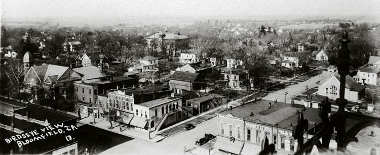
1923 Panorama photo looking NW from the top of the courthouse. (You can see the iron work that surrounds the statue in the lower right corner). Note the recent fire that has struck the Nazarene church in the middle of the photo. |
||
 |
 |
|||
1923, Looking due west from top of due West. Note in the distance on Jefferson Street, the bell tower of the SIN (Southern Iowa Normal) and the white tower of the Wallace house (SE corner of Bloomfield Ave & Jefferson Street. Also in the far distance on Jefferson Street you can see the Rock Island railroad trestle crossing over the street. |
The Human Fly, Henry "Dare Devil" Roland climbing the Marion County Courthouse in Marion, Kansas. On August 27, 1924 Roland attempted to climb the Davis County Courthouse. Read More about the Human Fly >>> |